
The Live Oak greeting you at Bly Gap...soon to cross over to NC.
Day Two of our virtual thru-hike.
I've decided to add a bit more realism to my hike by buying and preparing/eating some of the "trail foods" that are suggested for the AT. I'll share my experiences with those along the way.
This stretch is 88 miles and would normally take around 4 to 5 days.
Through the magic of virtual travel we will make it much sooner!
Come along...
The gnarled Oak tree above will be the first sign that you have reached North Carolina.
Called The Bly Oak, I fell in love instantly and MUST paint this landmark.
In Real Time, I would have spent an inordinate amount of time photographing the thing.

Although it looks like such a short jaunt on the map...it is actually through some of the highest mountains in North Carolina...and at 20+ miles a day...still takes over 4 days to hike.
The first stop this morning is High Top.

4037 feet in 1/2 a mile.
After a short descent- the trail climbs again to

I am beginning to see why this leg of the journey takes days!
When the AT descends it drops you into Sassafras Gap.

The Sassafras Gap Shelter


A Thru-Hike would be a horrible place to get sick.
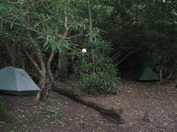
The Muskrat Creek Shelter


Vlog from Bly Gap/Dick's Creek to Muskrat Shelter by PT
https://youtu.be/En-4IKVlpDE
Close-up of Muskrat Creek Shelter
https://youtu.be/RdqwOTWD2GA
So far we have met Dixie and PT on the AT (above vlog), and I have been thinking a lot about this whole "trail name" thing...which seems important...and everyone takes one.
"Needs-More-Coffee" seems a mouthful.
"MC" is kind of a rip off of PT.
" Mo'Coffee" was too gangsta for me.
And Coffee-Beans...though appropriate I have shortened to "Beans"
(...also encompasses a few of my favorite things...human beans...coffee beans...cacao beans from which chocolate is made....jelly beans...pinto beans...)
Yeah...shortening my trail name to "Beans"
lol
So, that's sorted.
Leaving Muskrat Creek Shelter we now take the 8 mile uphill (up mountain?) hike to Standing Indian Shelter.
The Hike from Deep Gap to Standing Indian
https://youtu.be/ciT0dFcqm10
And I love the identification of various flora in this vlog from a dayhike.
The view from the top of Standing Indian Mountain.

The Cherokee Name for this mountain is Yunwitsule-nunyi,...translated to "Where the man stood" commemorating the tale of a Cherokee Warrior sent to protect this mountain.
It is 5500 feet high.
Hike to Standing Indian with "Redbeard" (Redbeard was hiking with "Toast" who hurt his leg and knee and is off the trail for awhile.)
https://youtu.be/49z1-D2sF_k
Standing Indian Shelter

The Shelter sleeps 8 and has numerous camping spots around its perimeter...also a privy.
As the trail continues down the mountain we will see
Beech Gap


I am loving all the interesting trees along the AT!!!
Through Coleman Gap to Carter Gap


Which also has numerous areas for primitive tent camping.
The AT continues through Betty Creek Gap and Mooney Gap and follows the Ridgepole Mountain.

View of Ridgepole from Betty Creek Gap
Although there is no shelter at Betty Creek...there are several cleared campsites.


(...as an aside...Mooney Gap is said to receive over 93 inches of rain every year...this may explain why most of the Georgia/ North Carolina trail hikes I have seen so far shows so many really rainy muddy slippery days...)
The trail now leads us to Albert Mountain
Rock Gap to Albert Mountain

As the terrain gets rockier and steeper...

.

A Video from the Firetower on Albert Mountain
https://youtu.be/RjzP1odcs4E
Standing Indian to Albert Mountain Hike
https://youtu.be/YKtVWkNNB_M
A short hike later brings us to where we will conclude today's journey at
Big Spring Shelter.

Big Spring Shelter
https://youtu.be/M8WQXt6CuA4
(...sadly this shelter has been torn down...forcing us to trek on to the newly built
Long Branch Shelter two miles further up the trail...)
Long Branch Shelter

17 miles from Franklin North Carolina on the Trail...this is sturdy and built to last.
Going to try the first of my trail food today with a trail-pack of Fettuccine Alfredo.
It is a just add to boiling water...let sit...and stir process. Can't get much easier than that.
250 calories
18 grams of protein.
Also Iron and Calcium.
The package weighs 4.4 ounces...a consideration when you are (actually) backpacking in food.
The blurb on the front boasts a beautiful bowl of Fettuccine Alfredo and the words
"Creamy Cheese Sauce and Pasta"

We'll see...and finish this blog after it is made.
On up the trail...
love
"Beans"

Okay....made the pasta.

Added cracked pepper...because...yeah...I pepper everything.
Easy one small pot and boiling water meal.
Quicky made...maybe 5 minutes. Sauce thickens more as it cools.
Pasta is pretty much what you expect from instant...thinner..shorter.
Sauce is rich...tastes great.
Probably better eaten with a spoon.
When cold congeals, and remainders leave the cooking pot in one solid mass.
Would make a great hot meal with very little prep...quick clean up...after a day hiking the trail!
