
And so we begin.
The trailhead at Springer Mountain.
They say the journey of 1000 miles starts with a single step. This is our journey of considerably more.
2,190 miles.
There are two ways to thru-hike the AT (Appalachian Trail). Southbound (SoBo) or Northbound (NoBo)
NoBo hikers start at Springer Mountain....usually mid-March so they can reach Maine by August or September (cold but not blizzards usually)
SoBo hikers start in May in Maine and reach Georgia while it is still relatively mild.
There are pros and cons to each trek.
Since this is virtual...we will be NoBo's.
A good introduction to the complete trail was recorded by "Dixie" (her trail name) on her first thru-hike.
I think my Trail Name would have to be something like "Needs-More-Coffee"
(...what would YOUR trail name be???)
Thru-Hike Conditions
https://youtu.be/EzXP5PjRHjM
I have to admit...after watching this in it's entirety...even "in my prime" I would only have been a fair-weather hiker. Beautiful sunshine and wildflowers and mountains streams are fine. Days of pour-down rain, mud and slippery clay, freezing temps, snow and ice...yeah...going to have to take a lot of ZERO days (...when you stop and do no miles for the day...)
But here we go!
The Trail runs 78.6 miles through Georgia beginning at Springer Mountain Trailhead. (Shown above)
This is in Amicalola State Park.
And is called the Appalachian Approach Trail.
It would normally take 3-4 days to cross Georgia...but today through the magic of cyber-space...we will see the State Line today.
Amicalola Falls is near the trailhead.

A gorgeous way to begin our adventure.


Three Forks


Springer Mountain Shelter
for Thru-Hikers.

The Housatonic River and Falls.


Approaching Springer Mountain Summit.
And the Summit View

The Shelter at Blood Mountain (the next on the trail through GA)

These Shelters are rudimentary for those who do not bring tents to sleep out of the elements.
They are scattered along the length of the AT and are free.
Neel's Gap and Falls

More hiking at Blood Mountain

The Large Shelter at Neels Gap.

To Tray Mountain


Tray Mountain Summit


A valley in Towns Country, Georgia named after an American-Indian gravesite and cairn found there.

Onward to Dicks Creek Gap

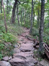
The Trail

Dicks Creek

Neels Gap to Dicks Creek Trail

Shelter at Dicks Creek Gap

Dicks Creek Falls

And at last to Bly Gap


I LOVE this tree!

Full Trek from Springer Mountain to Bly Gap
Part I to Woody Gap
https://youtu.be/AxkdNZQF-9w
Part 2 Woody Gap to Neel Gap
https://youtu.be/NKQVIMoLlKI
Part 3 Neels Gap to Lower Gap Shelter
https://youtu.be/zQqisDOGjpU
Part 4 Low Gap to Tray Mountain
https://youtu.be/lVBGw83XpwA
Part 5 Tray Mountain to Bly Gap
https://youtu.be/peNNzcSJPFY
Okay...he lied. The Vlog only takes us as far as Big Gap...WTH???
Did he just give up or what?
...lightweight...
Next time we will explore the North Carolina section of the AT.
More Anon...
